Mobile SDK

A ready-to-use set of tools and libraries to embed a complete map, search, and navigation into your mobile app on iOS and Android

main_title_block_image
license

Geodata complies with OGC standards

user

Your profile can be used to create a demo key, view daily statistics for all keys and set a limit for HTTP-headers, IP, and subnetworks.

sdk

The SDK is adapted for development in modern programming languages

wifi

Data can be used offline, without an internet connection

like

We accompany customers in all processes and provide a free key for testing

Give your app the power of geodata

Maps

Beautiful, detailed, and accurate 3D maps on which it’s convenient to change the inclination, turn on smooth flights, animation. You can add immersive models of objects, floor plans of buildings, or change the appearance and any information on the map to suit your needs in the Style Editor. Maps can work offline without an active internet connection.
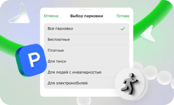
Smart search

It solves the problems of geocoding and searching for any objects in the city for any queries: from the name of the site to the phone number and TIN — taking into account typos, incomplete queries, and common names. We take into account geolocation and popularity of the units. We know how to personalize the search results.

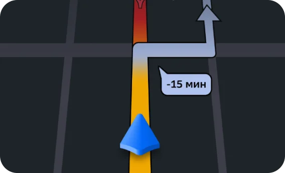
Routes and navigation

We build and show routes for different types of transport in the mobile interface — for cars, including trucks, all types of public transport, bicycles, scooters, and pedestrians. To assess the exact time of arrival, we take into account ETA/RTA, help to choose the optimal speed limit and route. Use all this in your Mobile SDK-based application.

phoneiphone2iphone3
mobileSdkBgLine2mobileSdkBgBlur2GisLogomobileSdkBgLine1

Choose your SDK

Basic

Map
Search
mobileSdkCardBaseBg

Extended

Map
Search
Building routes
mobileSdkCardAdvancedBg

Full-fledged navigator

Documentation for iOS and Android

Map
Search
Building routes
Additional features
mobileSdkCardTaxiBg
Full customization. Change the interface of the navigator to meet the goals and functions of the application.
mobileSdkCardParkingBg
The navigator knows the opening hours of parking lots and their cost. Parking places are marked on the map in the navigator mode, paid ones — immediately with the price.
mobileSdkCardVoicesBg
The way will be shown by star voices: Nikolay Drozdov, the SBPCh band, a voice from VHS tapes from the 90s, Matroskin the cat, and others. The navigator gives detailed instructions for each section of the route — on the screen and by voice.
It leads past traffic jams, closures, and standard routes, chooses the most convenient route, and gives accurate instructions on the way even offline.
All types of routes: for cars, trucks, scooters, bicycles, and pedestrians. For trucks, we take into account the dimensions and areas with restricted travel.
We monitor the speed, we know all the limits. We will take into account signs, lanes, and traffic cameras. We will build a passage based on information about traffic, closures, and traffic rules so that the driver gets the fastest and most optimal route.
mobileSdkCardTrafficBg
Real-time updates on traffic jams and events. Constant search for the best routes: the navigator will show several ways to get there and will suggest new ones if the best route is found during the trip.

Didn’t find the right product to solve your problem?

We take on complex non-standard tasks. Tell us about the project, we will find a solution.

Four reasons to choose 2GIS

dataDependent

At the heart of all decisions, data that we ourselves collect and update

experience

Since 1999, we have been working with data you can trust

accuracy

Accuracy of 2GIS data is 95%. Let’s explain how we achieved this

trust

We are trusted by thousands of clients in Russia and the CIS countries

Tell us about the task and we will help you solve it

logo
Russia
By clicking the Send a request button, you accept the terms of the License Agreement. Conditions and objectives for processing of personal data are defined in the Privacy Policy. Personal Data Processing Policy.
Contact number+7 966 500-00-50